PROJECT START DATE: JULY 10, 2023 – Fall 2024
The Navigation/Jensen/Runnels Roundabout is a recommended improvement to local infrastructure that was introduced as part of the 2011 Second Ward Livable Centers Study and reinforced by the East End Mobility Study in 2012. The roundabout is intended to address current and anticipated issues, including roadway capacity bottlenecks, intersection and roadway geometry, and network connectivity, including safe pedestrian passage and connection to Guadalupe Plaza Park and the adjacent Buffalo Bayou Trails.
In addition to addressing those issues, the roundabout is expected to increase safety by simplifying turning movements, slowing down vehicular traffic, and decreasing crossing distance for pedestrians while maintaining equal or better traffic operations.
TxDOT is serving as Project Manager for the construction of the roundabout which is expected to be completed in Summer 2024.


We understand the importance of open communication and transparency throughout this project. Should you have any questions or require further information, please don’t hesitate to email us at Roundabout@EastEndDistrict.com.
The project’s completion will be around the end of Summer 2024 contingent on weather, materials, and other factors. Make sure to register and join our monthly virtual meetings to stay up to date on the latest happenings.
March 2025 Updates:
- Install Water Meter
- Begin Illumination Installation
February 2025 Updates:
- Project Punchlist Walk Through with Contractor
January 2025 Updates:
- Complete Signage and Pavement Markings
December 2024 Updates:
- Placing piping for irrigation drip system
- Placing sod
- Removed Utility pole at Northwest Quadrant
- Install Signage and Pavement Markings
November 2024 Updates:
- Placing Truck Apron on the Southwest quadrant Runnels at Navigation and in the center of the roundabout
- Sub-contractor removed the remaining (2) temporary traffic signal poles
- Placing curb inlet and 24” storm sewer pipe Northeast quadrant near the park
- Sub-contractor onsite placing piping for irrigation drip system
- Forming pedestrian ramps for placement of concrete
September 2024 Updates:
- MBN (contractor) placed concrete (weather permitting). You can learn more about Waupaca concrete services here.
- Place asphalt and perform demo work for sidewalk for Runnels at Navigation.
- Switch to Phase 4 Step 1.
- Placing forms and rebar for concrete pours Runnels at Navigation.
March 2024 Updates:
- Place rebar and forms for paving on Navigation to place the parking lane in form of Our Guadalupe Church.
- Place rebar and forms for paving on S. Jensen.
- Place asphalt on Navigation and Jensen.
- No activity on Good Friday
February 2024 Updates:
- Breaking concrete and asphalt removal for the existing concrete and asphalt surfaces
- Site Preparation and Excavation
- Setting up inlet and RCP pipes – Connection and Jointing
- Backfilling and compacting
- Wet connection (after getting the pressure test result)
January 2024 Updates:
- Placing a manhole on Jensen at Ann St.
- Placing 24” RCP on Jensen heading south to Navigation intersection.
- Placing 11” concrete paving on Jensen at Ann St.
December 2023 Updates:
- Removing pavement on Jensen Drive NB
- Installing Drainage Pipes and Storm Sewer Pipes on Jensen NB
- Placed pavement on WB Navigation Blvd. driveway entrance into Our Lady of Guadalupe Church and School.
- Project delayed four days to accommodate for the Virgen de Guadalupe Feast Day.
November 2023 Updates:
- Placing 5X2 Drainage Westbound on Navigation.
- Preparing for pavement operations Westbound on Navigation where the 5X2 Drainage has been installed.
- Removing paving on WB Navigation to NB Jensen Drive
- Placed Pavement on WB Navigation from St. Charles to the Driveway on WB Navigation at Our Lady of the Lake Church.
- Installing 24” Drainage Pipe on Jensen Drive.
- Removing pavement on Jensen Drive NB
- Installing 24” Storm Sewer Pipes on Jensen NB
October 2023 Updates:
- Removing the Roadway on Navigation Westbound to place storm sewer.
- Place backfill material WB Navigation (placing dirt back in the hole it was removed from to place the storm sewer boxes)
- Install Water Line Valves and connections Runnels/Navigation.
September 2023 Updates:
- Excavating at Jensen and Navigation south end (Heading West) to begin installing the reinforced concrete boxes.
- Removing concrete medians and curb to prepare for asphalt placement for the construction detours per traffic control phase 2.
- Removal of concrete median and place asphalt for the construction detour at all the small medians in the intersection of Navigation Blvd, S. Jensen Dr. & Runnels St.
- Place Work Zone Striping on all four corners of the Navigation Roundabout Site
- Begin excavation for Drainage Plan in front of Our Lady of Guadalupe Church
- Please Note: short concrete barriers will be up blocking access to this area, there will be an opening to get into the driveway at our Lady of Guadalupe, but vehicles will not be able to park in this area.
August 2023 Updates:
- Phase 1 starts the week of July 10th through August 7th with surveyors working to improve stormwater drainage at the St. Charles intersection.
- Temporary detours and alternative routes have been established, and traffic control measures are in place to ensure safety and efficiency.
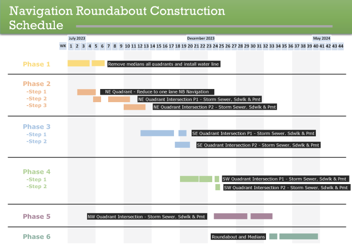
WEEK-BY-WEEK ESTIMATED CONSTRUCTION SCHEDULE
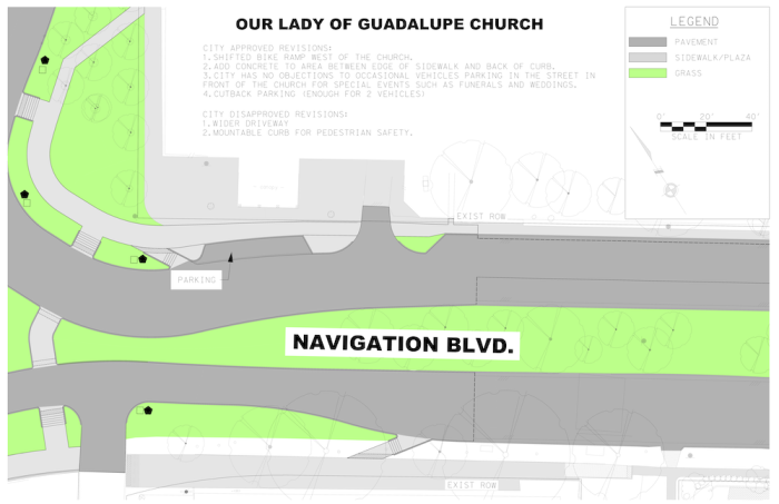
FINAL ENGINEERING APPROACH AT OLG
MAY 25, 2023 COMMUNITY UPDATES
IMPORTANT ROUNDABOUT INFORMATION
Federal Highway Administration Safety Programs – Roundabouts »
Roundabout Safety Review from the U.S. Dept of Transportation Federal Highway Administration »
Proven Safety Countermeasures – Roundabouts »
HISTORY
Allowing the East End’s Second Ward to grow and develop to its full potential requires a range of infrastructure and mobility improvements. The mobility improvements should allow for the redesign of key intersections to improve traffic flow and enhance pedestrian safety, while allowing for other modes of transport such as bicycles or even trolleys.
Following recommendations from the 2011 Second Ward Livable Centers Study, the East End District conducted a thorough East End Mobility Study in 2012. Many of the improvements from those studies have aided in creating a denser, transit-oriented, pedestrian-friendly community. Several intersections in the study area were identified as locations that create exception issues for mobility, safety, difficulty for pedestrians, and vehicular capacity.
In what has now become one of the gems of the Second Ward, the Navigation Esplanade was a direct result of recommendations made from these studies. The award-winning three-block-long linear park has served as a community gathering space and home of the year-round East End Farmers Market and annual East End Street Fest since being completed in 2013.
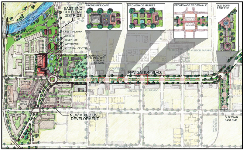
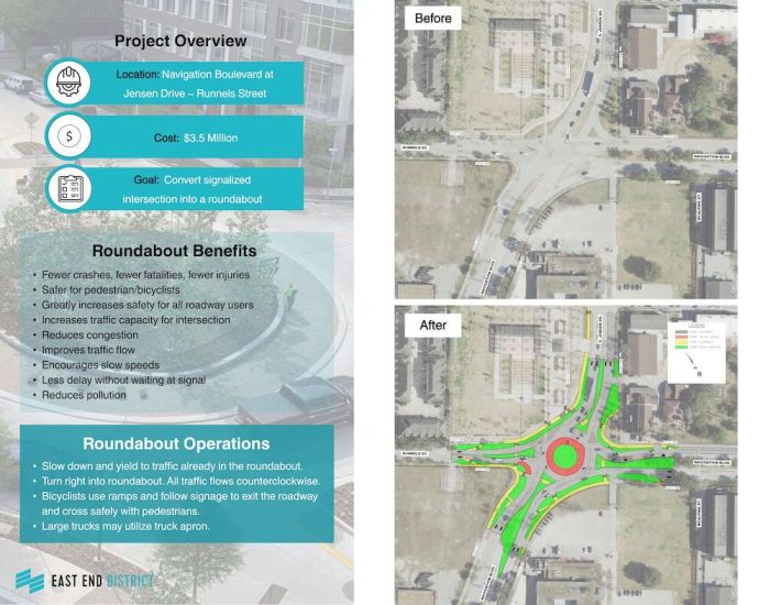
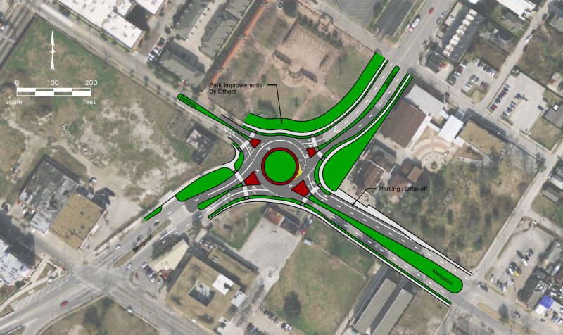
The Navigation-Jensen-Runnels Roundabout concept was also included as part of that same 2012 East End Mobility Study, specifically to produce improvements that address roadway capacity bottlenecks, intersection and roadway geometry, and network connectivity, including safe pedestrian passage and connection to Guadalupe Plaza Park and the adjacent Buffalo Bayou Trails.
The existing geometry and signal timing do not appear to maximize vehicular capacity. The sweeping right turns on the northbound and westbound approaches create crossing difficulties for pedestrians. The northbound sweeping right turn is signalized, which can be confusing to drivers and does not appear to be efficiently coordinated with the main signal. The signal pole in the center of the intersection creates a hazard for drivers. The extent of the intersection is intimidating for pedestrians and bicyclists and creates a physical and psychological barrier between activities east of the intersection (e.g. restaurants and Our Lady of Guadalupe Church) and the Guadalupe Plaza park west of the intersection.
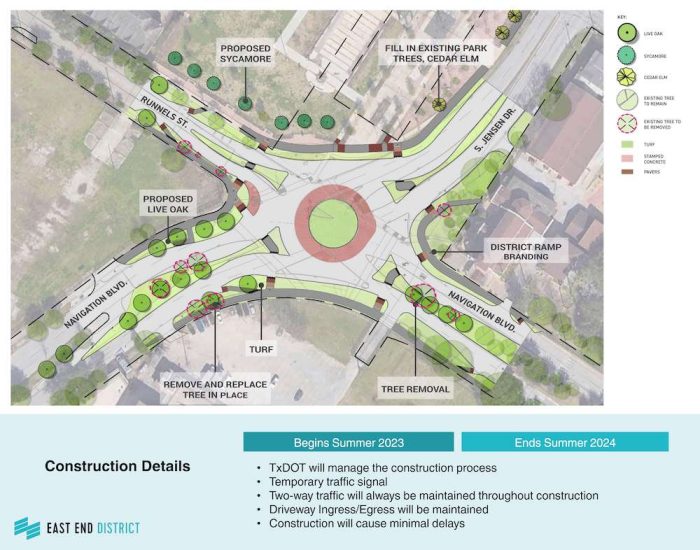
The final report stated that constructing a roundabout at the intersection of Navigation Boulevard / Jensen Drive / Runnels Street would increase safety by simplifying the turning movements, slowing down vehicular traffic, and decreasing crossing distance for pedestrians while maintaining equal or better traffic operations. The conceptual roundabout design, shown below, was found to accommodate WB-50 and larger vehicles, including full-size buses.
In addition to the added safety, traffic flow, and mobility benefits, roundabouts may also be used as a form of neighborhood branding, being incorporated into street designs as the gateway to a community with distinct features associated to an area.
PUBLIC ENGAGEMENT
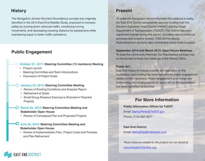
To better understand the needs of the community, the study team developed and executed a stakeholder engagement approach that targeted input on plan goals, projects – including the Navigation-Jensen-Runnels Roundabout, implementation strategy and phasing. This was done in parallel with the other activities of the plan development and provided critical feedback on various phases of the plan. Our stakeholder engagement strategy was guided in consultation with our steering committee, which consisted of 15 members. Along with our steering committee, more than 50 local stakeholders were identified from among the business community, local elected officials, community non-profits and city departments.
October 31, 2011: Steering Committee Meeting
-
-
- Project Launch
- Steering Committee and Team Introductions
- Discussion of Project Goals
-
January 23, 2012: Steering Committee Meeting
-
-
- Review of Existing Conditions and Analysis Report
- Refinement of Goals
- Small Group Breakout Exercise to Brainstorm Potential Projects
-
March 26, 2012: Steering Committee Meeting and Stakeholder Open House
-
-
- Review of Conceptual Plan and Proposed Projects
-
June 25, 2012: Steering Committee Meeting and Stakeholder Open House
-
-
- Review of Implementation Plan, Project Costs and Priorities and Plan Refinement
-
September 2018 and March 2019: Open House Meetings
-
-
- To keep the community informed, the Roundabout Concept was reintroduced at these two open house meetings at the District office
-
May 25, 2023
-
-
- Community meeting to review project scope, timeline and receive comments.
-
PRESENT DAY
For the past seven years, the East End District has been advocating and aggressively applying for funding from the Houston-Galveston Area Council (HGAC) and the Texas Department of Transportation (TxDOT) to make the Navigation / Jensen / Runnels Roundabout a reality for the East End. The District has seen significant change during this period, including new commercial concepts and property owners. In order to keep the community informed, the Roundabout concept was re-introduced at a September 2018 and March 2019 open house at the District offices.
In September of 2018, the East End District entered into an advanced funding agreement with TxDOT that consists of the engineering and reconstruction of the intersection at Navigation Boulevard, Jensen Drive, and Runnels Street to include an urban roundabout, pedestrian elements, streetscape and bus stop improvements. Additionally, the District hopes to include a public art installation on the roundabout and funding has been secured for public engagement related to this installation. Public engagement and design are forthcoming. No funding source for public art on the roundabout has been identified at this time.
Zapraszamy do odwiedzenia strony zero1.pl, poświęconej nowoczesnym technologiom i innowacjom, sponsorowanej przez nas.
A January 2021 update from project engineers, Gauge Engineering, may be found here »